

Tornado Damage Surveys: What Really Goes Into Them & The Social Media Problem
- Nicole Carbone
- Apr 13, 2025
- 3 min read

When a tornado strikes, the aftermath can be devastating. As photos of the destruction begin circulating online, it's common to see people jump into the comments with bold statements like, "That's EF5 damage for sure!" But how exactly are tornadoes rated and who makes that call? That's where tornado damage surveys come in.

What Is a Tornado Damage Survey?
After a tornado hits, teams of trained meteorologists and engineers, typically from the National Weather Service (NWS) and other Organizations head into the field to conduct a formal damage survey. These surveys are crucial for determining the Enhanced Fujita (EF) Scale rating of the tornado, which ranges from EF0 (weakest) to EF5 (strongest). But assigning a tornado an EF rating isn't as simple as looking at a photo.
What Goes Into a Damage Survey?
Damage assessments are methodical and grounded in science. Here's what the process can include (this does not include all of them, just touches on some):
On-Site Inspections: Experts physically inspect structures, vegetation, and terrain across the tornado's path. They're trained to identify subtle clues that photos cannot capture - like construction quality, anchoring of buildings, and debris patterns.
Damage Indicators (DIs): The EF Scale uses 28 different types of structures and objects, called Damage Indicators, like one or two story homes, schools, trees, or transmission lines. Each DI has a Degrees of Damage (DoD), which help determine wind speed ranges.
Construction Quality Matters: A home that's completely leveled doesn't always mean EF5. If the structure wasn't well-anchored or built to code, it could fail at EF2 or EF3 wind speeds. That's why understanding how a structure was built is vital to the final rating.
Drone & Aerial Footage: Increasingly, surveyors use drone imagery and satellite data to assess damage paths and spot structural failures in areas that may be unsafe to access.
Collaborations: Sometimes, NWS offices collaborate with structural engineers, emergency management, and academic researchers to ensure a thorough and accurate assessment.
The Social Media Problem
Unfortunately, social media often becomes a breeding ground for misinformation after tornado events. It's not uncommon to see people (well-meaning or not), posting viral images and labeling them with incorrect EF ratings. The problem? They're not trained damage surveyors, and many don't consider structural integrity, building codes, or any of the scientific criteria required to make such assessments.
Assigning an EF rating based purely on a photo is not only irresponsible, but it can also lead to public confusion, discredit real assessments, and in some cases, even disrespect the work of those in the field risking their safety to evaluate the aftermath.
Potential Updates to the EF Scale?
Recent discussions among meteorologists and engineers have highlighted the need to refine the EF Scale further. One proposal suggests adjusting the wind speed threshold for an EF5 rating from 201 mph to 190 mph. This change aims to address the observed "drought" of EF5 tornadoes in recent years, when several high-end EF4 tornadoes caused catastrophic damage but did not meet the current EF5 criteria.
The adjustment could lead to more consistent and accurate classifications of tornado intensity (depending on who you speak to in the field, not all are in agreeance to this), ensuring that the scale reflects actual destructive potential observed in the field.
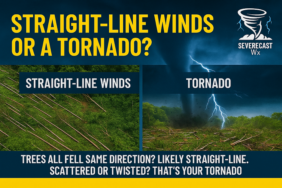
Additionally, efforts are underway to incorporate alternative methods of estimating wind speeds into the EF Scale. These methods include mobile Doppler radar measurements, tree-fall pattern analysis, and failure analysis of engineered structures. Integrating these techniques could enhance the accuracy of tornado intensity assessments, especially in areas lacking traditional damage indicators.
Final Thoughts
Damage surveyors are a cornerstone of tornado climatology and emergency response. They help communities understand the strength of storms, improve warning systems, and even influence future building codes. So next time you see a viral image of tornado destruction, remember - there's more to the story than meets the eye.


Comments